


The storm made landfall Wednesday night near Siesta Key, Florida.
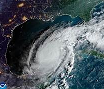
Hurricane Milton made landfall near Siesta Key, Florida, at approximately 9:30 p.m. local time on Wednesday. The storm hit with maximum sustained winds of 120 mph, making it a Category 3 hurricane at the time of landfall. The National Hurricane Center (NHC) issued urgent warnings about the immediate threats, including life-threatening storm surges, extreme winds, and flash flooding over the central peninsula of Florida. These conditions were expected to cause significant disruption as Milton moved further inland.
In the hours following landfall, the storm began to weaken slightly, and by 10 p.m., the NHC downgraded it to a Category 2 hurricane, with sustained winds of 110 mph. Despite the downgrade, the storm continued to cause widespread concerns for residents and officials, especially as it moved across central Florida. The threat of flash flooding, particularly in low-lying and coastal areas, was expected to intensify through the night.
Authorities had already issued a series of evacuation orders in the hardest-hit areas, urging residents to take shelter away from flood zones and prepare for the severe weather. In the affected areas, people were advised to secure their homes, stay indoors, and follow updates from local officials regarding road closures and safety advisories. The NHC confirmed that several roads were already impassable due to flooding.
Tampa and Sarasota were among the cities most affected by the storm’s landfall, with high winds and heavy rains hammering the area throughout the night. The NHC reported that storm surges of up to 15 feet were possible along the coastline, which could lead to significant flooding, particularly in coastal communities. As Milton continued its path, the risk of further damage, especially from flooding and fallen trees, remained high.
Milton’s rapid intensification over the Gulf of Mexico had already caught the attention of meteorologists, who were astounded by how quickly the storm grew in strength. This intensified storm caused some alarm as it approached the state, with residents rushing to prepare for the worst. Shelters were opened ahead of the storm’s arrival, and many local businesses were forced to close early as a precaution.
The NHC warned that the storm’s impacts would not end with the landfall. Even as the storm began to weaken, Milton’s broad reach meant that much of the state would continue to experience strong winds and heavy rain. Flash flooding was expected to be a continuing threat into Thursday morning, as the storm moved across Florida. As of the latest updates, the NHC stressed the importance of remaining indoors, avoiding unnecessary travel, and staying informed about changes in the storm’s path.
For now, officials are closely monitoring the storm’s progress and its impact on vulnerable communities, urging everyone in the affected areas to heed the warnings and avoid putting themselves in danger. The full extent of the damage will likely become clearer once the storm has passed, but for now, the primary concern is ensuring the safety of residents and minimizing the risk of further harm.