


Investigating the Causes Behind the Collision and the Response Efforts
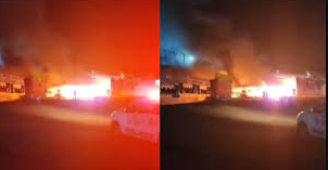
Using a combination of flight tracking data, air traffic control recordings, and CCTV footage, Sky News’ Data and Forensics Unit has reconstructed the tragic events of the Washington plane crash, which is believed to have resulted in 67 fatalities.
At 8.47 pm, as the aircraft was flying at 600 feet and preparing to cross the river, the air traffic controller alerted the military helicopter pilot, instructing them to pass behind the passenger jet. “PAT25, do you have the CRJ in sight? Pass behind the CRJ,” the controller advised.
Just seconds before the collision, airport security cameras captured the military helicopter on a direct path towards the plane. Flight tracking data confirmed the plane’s last reported altitude of 275 feet at 8.48.03 pm, moments before it disappeared from radar.
As the crash occurred, the sound of a gasp echoed through the air traffic control room. “Did you see that?” one controller asked. An emergency alert was issued roughly one minute later, at 8.48 pm, announcing “Crash crash crash – this is Alert 3.” The call confirmed the collision involved a helicopter and a passenger jet near runway 3-3.
By 8.53 pm, reports of the crash reached police, and emergency responders were on the scene by 8.58 pm, confirming the aircraft had ended up in the water. The search and rescue operation was launched at 9.04 pm, with the first rescue boat arriving at 9.11 pm.
What caused the crash?
Transport Secretary Sean Duffy called the crash “absolutely preventable.” He responded to questions about whether the plane was aware of the helicopter’s proximity, stating that the helicopter pilot was likely aware of the plane’s location.
Flight tracking data, however, shows that the military helicopter had climbed to 300 feet—100 feet above the advised 200 feet altitude for helicopters in that area, as indicated by a map from the Federal Aviation Administration (FAA). It remains unclear whether the helicopter pilot took any action following the air traffic controller’s warning.
Aviation security expert Andrew Nicholson of Osprey Flight Solutions noted that Black Hawk helicopters are typically well-equipped to avoid obstacles, but several factors could have led to this crash. Michele Robson, a former air traffic controller, suggested that the instructions provided by air traffic control may have been insufficiently clear. Robson argued that specifying the airline involved would have prevented confusion, particularly as another aircraft, an Airbus A319, was also in the helicopter’s line of sight.
“Given the distance of 9.2 km, the helicopter pilot might have mistaken the Airbus for the smaller American Eagle plane that was closer, at 4.5 km,” Robson explained. “The dark city environment and the lighting could have made it difficult for the helicopter pilot to identify the aircraft accurately, especially at such a distance.”
This incident highlights the importance of clear communication and precise actions in preventing aviation disasters. As the investigation continues, the public awaits further details on what went wrong and how such tragedies can be avoided in the future.
The Data and Forensics team at Sky News continues to analyse and visualise data to uncover the full story behind the crash and its aftermath.